|
Published: 25 October 2010
Waterbirds waste no time exploiting wetland bonanza1
Earlier this year, torrential rain fell in the Channel Country in far western Queensland – hard on the heels of heavy summer rains and the 2009 inundation of Lake Eyre. The unpredictable cycles of flooding in the Lake Eyre Basin have always attracted waterbirds from afar. Now, with the gradual deterioration of wetland habitat in the Murray–Darling Basin, the Channel Country may have become the ‘breeding powerhouse’ for at least 25 waterbird species.
|
|
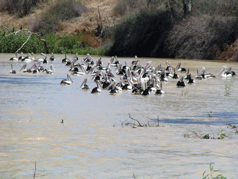
Pelicans on the Cooper Creek. Credit: David Roshier
|
The Channel Country encompasses a complex system of river channels that are mostly dry, but occasionally wet.
On average, the three major river systems – Cooper Creek, the Diamantina River and the Georgina River/Eyre Creek – flow about half the time, although the number of days on which they flow varies greatly from one year to the next. Their annual discharge is also highly variable, and falls within the highest inter-annual variability in the world for large rivers.
The catchments of the Channel Country’s major river systems begin hundreds of kilometres to the north and east, feeding floodwaters from monsoonal Australia into Lake Eyre. The slow passage of floodwaters across flat, extensive floodplains enables enormous aquatic productivity. The defining characteristic of these great unregulated rivers is the intricately braided and anastomosing pattern of flowpaths – the criss-crossed ‘channels’ that give the country its name.
Following the flow
Waterbirds have a remarkable ability to find the most productive wetlands across the Australian continent and within the Channel Country. In years when there are marked contrasts in flood size between the three main rivers, waterbirds head for the biggest inundated floodplains.
Although the mechanisms by which waterbirds are able to detect far-off floodwaters remain an intriguing mystery, their ability to do so is beyond doubt. Recent research has shown that individual grey teal birds have remarkably precise means of navigation across many hundreds of kilometres of inhospitable country.2 They find tiny water bodies in otherwise waterless landscapes by following the equivalent of detailed internal maps, adding to their store of knowledge each time they cross new country.
Even when flooding is widespread and general across the Channel Country, differences in catchment characteristics and river length mean that wetlands are created earlier in the Diamantina River than on the other two rivers’ floodplains, with floods proceeding more rapidly. This out-of-phase flooding, and the phase shift – the length of time that the stage of flooding in the Cooper and Eyre Creek wetlands lags behind equivalently located wetlands on the Diamantina River – increases as the floods slowly roll down each river.
|
|
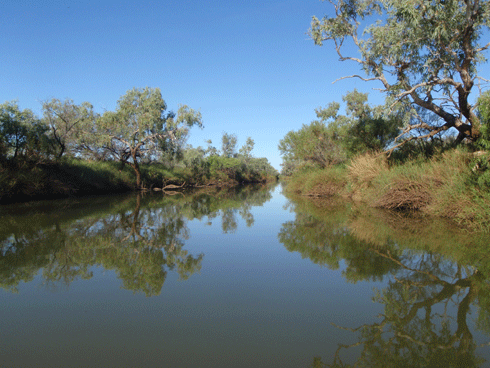
Like many other ephemeral watercourses, the normally dry sand-bed of the Mulligan River was unrecognisable after the floodwaters arrived. Credit: Adam Kereszy
|
Wide-ranging waterbirds are uniquely poised to capitalise on these hydrologically staggered events, and shift their centres of feeding and breeding activity across and along the different rivers as the floods progress.
Over the duration of a large flood event, there is a well-documented movement of waterbirds away from the transient desert channels floodplains to the more persistent downstream lakes along the Eyre and Cooper Creek systems, including Lake Eyre itself. Four to eight million waterbirds across 70 species were estimated to be in the Channel Country after a large flood in 2000, based on aerial surveys and targeted ground surveys. Approximately 40 species were detected breeding.
A total of almost 90 species of waterbird has been recorded in the Channel Country. Ignoring the few wetland raptors and bush birds, and four species of aberrant shorebird that are not tied to wetlands, at least 21 species of migratory shorebird are non-breeding visitors to the region. Although only half of these occur regularly, the Channel Country provides significant overwintering habitat for a few species, notably the sharp-tailed sandpiper and little curlew.
The timing of floods in late summer makes the area an important stopover for more species on their northward migration. Even greater numbers of breeding Australian shorebirds occur in the Channel Country, and together the two groups of shorebird comprise 40 per cent of waterbird species, and up to 25 per cent of total abundance. Two-thirds of the waterbird fauna (58 species) are known to breed in the region.
Although big floods only occur every few years, the Channel Country in flood has a magnetic attraction for waterbirds from much of the continent, and the urge to breed creates massive influxes. Although there have been no studies of reproductive success in the region, the Channel Country in times of big flood is surely among the most productive wetland regions in Australia in terms of waterbird recruitment (number of fledglings produced to independence per breeding unit). One example was the gathering of 70,000 pairs of Australian pelican to breed at one colony on the Eyre Creek in 2000; most pairs were thought to have successfully fledged one chick each. Smaller colonies were scattered around the Channel Country, so it is likely that most of the entire population of this species was present in the region at the time.
The Channel Country booms in waterbirds are explained by immigration – mainly from outside the basin – and high rates of reproductive success. For most species, there is insufficient time for that season’s progeny to grow to breeding age in the same flood. They, and the adults, are forced off the floodplains as the waters recede. A great exodus begins, perhaps initially to flooded areas further downstream, and to the lakes within the region and downstream; but, for most species at least, to better-watered peripheral parts of the continent.
These eruptions out of the Channel Country are most noticeable when they involve species not normally present in coastal and southern (populated) regions. The most spectacular waterbird example is the black-tailed native-hen, which visits southern Australia in huge numbers in some years, before suddenly disappearing again. Adult black-tailed native-hens, it seems, can successfully raise two broods during a large desert channels flood, and so contribute to a greater within-event population increase.
Channel Country wetlands function as the core of an impressive central–eastern Australian engine room, which includes other wetlands in the Lake Eyre Basin, and similarly productive catchments to the north (Barkly Tablelands) and east (Bulloo, Paroo). They may ultimately prove to be the breeding powerhouse for as many as 20–25 Australian waterbird species. Despite breeding events varying enormously in size from one year to the next, the high rates of reproductive success, combined with sheer abundance of nesting birds, could mean that the region now contributes more individuals to the populations of these species than any other wetland region in Australia.
Although the Desert Channels region3 has always been important to waterbird recruitment, it is only recently that its significance has begun to be understood. Its primacy – if that is indeed its position for the 20–25 species – may have arisen only recently, as a consequence of the collapse of wetlands in the historically more important Murray–Darling Basin through vegetation clearance, irrigation development, over-extraction of water and declining runoff in the last 20 years. The Murray–Darling Basin was historically the most important breeding region for the majority of inland Australian species of waterbird (excluding tropical waterbirds), but is perhaps no longer.
|
|
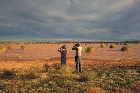
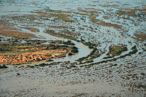
Desert channels: waters from far away Queensland found their way to the Simpson Desert earlier this year. Credit: Adam Kerezsy
|
This does not imply that the Channel Country and adjacent wetland regions can sustain, in isolation, waterbird populations at current levels. First, because arid-zone wetlands dry out periodically, waterbirds are totally dependent on wetlands in other regions – drought-refuge habitats – for survival. Second, the continental network of wetlands needs to be maintained (and restored in overdeveloped regions) more generally, to retain opportunities for waterbirds to move freely around and across landscapes, and to breed in a range of places.
Identification and protection of the major waterbird breeding colonies requires further investigation, especially given the parlous state of breeding grounds in the Murray–Darling Basin.
|
The black-necked stork, or jabiru, is a bird normally found in coastal wetlands. But this year, it is just one of many unusual visitors to the Channel Country,4 attracted by the rich bounty of the flooded interior. |
For Bush Heritage ecologist Dr Max Tischler, the unexpected sighting of jabiru and other species that he has never seen in the area before is an indication of what an exceptional year it’s been in the outback. |
On a recent trip to Bush Heritage’s Ethabuka property in the north-east corner of the Simpson Desert, Dr Tischler saw desert short-tailed mice, which haven’t been recorded there for 18 years. And, in the river systems, fish are being found that were previously unheard of in these parts, such as Hyrtl’s catfish and Lake Eyre hardyhead. |
Dr Tischler says plant species that have lain dormant in the seed bank for many years have broken their dormancy and germinated in response to massive early-season rains. |
‘Since the rainfall and flooding, there’s been a big flush in vegetation and insects, followed by many other animals responding,’ he says. |
‘Some of the smaller mammals have started to go into rapid reproductive cycles, a lot of birds have moved into the area and started to breed, and the waterholes are full of fish.’ |
Dr Tischler says the small mammals provide a good example of adaptation to living in the boom-bust cycle of the arid zone. |
‘In good conditions, some of the small rodents seem to be everywhere but when it turns dry they just disappear,’ he says. |
In poor conditions, many native mammals such as rodents and dunnarts maintain low numbers, which are confined to small areas ready to respond to a rainfall event or a pulse in resources. |
‘We have been trying to determine where these areas are, and to identify the cues that they need to increase in numbers and really hit their straps in a boom period,’ Dr Tischler explains. |
He says a feature of this year’s flooding is that it follows several years of above average rainfall. |
‘Usually, you would have a wet year maybe one in every six or seven years. Long-time observers are saying there hasn’t been a year like this since the ‘70s; it’s really exceptional circumstances,’ he says. |
With so much flooding – from western Queensland through central Queensland, along the Murray–Darling Basin and much of inland New South Wales, the waterbirds, which are just starting to breed, are quite dispersed. |
‘Now the water is starting to shrink back to the more permanent waterholes, we are seeing big concentrations of pelicans, swans and cormorants,’ Dr Tischler observes. |
On a trip sampling waterholes along the floodplains of the Mulligan River in western Queensland, he found 40–50 different waterbirds on some waterholes, many of which were attempting to breed. |
‘I’ve been working out there for about 12 years, and I’ve never seen so much water through the landscape, such a massive amount of fish in those waterholes, or such a large number of birds using those resources,’ he says. |
Dr Tischler says one of the most intriguing aspects of the response is the immigrant birds’ ability to detect the presence of water from so far away. |
‘The pelicans are a classic example. They can somehow detect a storm system and a weather front far inland and make that journey. |
‘It’s one of those questions that science has been trying to answer for a long time – how do those birds on the coast know when there is rainfall in the centre of the country?’ |
He says it’s likely they pick up some sort of environmental cue, such as a change in barometric pressure, and then decide to take the gamble. |
Very little work has been done recording these sorts of responses to wet conditions in the arid centre, so the observations that Dr Tischler and his fellow researchers make will provide essential information for future management of the landscape. |
1 This is an edited excerpt from the new book, Desert Channels: The Impulse to Conserve, published by CSIRO Publishing. See www.publish.csiro.au/pid/6406.htm
2 See Roshier D et al. (2008). What drives long-distance movements in the nomadic Grey Teal Anas gracilis in Australia? Ibis 150, 474–484.
3 The Desert Channels region is defined as the north-eastern part of Lake Eyre Basin in far west Queensland. The smaller Channel Country is area 1 of seven ‘bioregions’ within the Desert Channels; it includes Birdsville, Bedourie and Windorah.
4 See also Baxter CI, Reid JRW and Jaensch RP (2001). First South Australian records of the Black-necked Stork Ephippiorhynchus asiaticus and occurrence of vagrants in south-western Queensland. South Australian Ornithologist 33, 164–169.


