Print this page

Published: 25 October 2010

After the fire: Leadbeater’s long journey

David Lindenmayer, Sam Banks, Lachlan McBurney and David Blair

Life is slowly returning to the wet mountain ash forests burned in Victoria’s 2009 Black Saturday fires. Yet, the future of these forest communities – symbolised by the iconic Leadbeater’s possum – is by no means guaranteed, warns a group of ecologists in their compelling new book, Forest Phoenix.
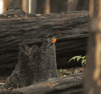
The orange flash of the Flame Robin is now a common sight in charred Montane ash forests.
Credit: David Blair

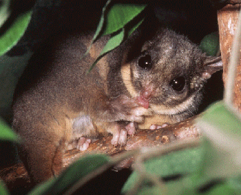
Montane ash forests are truly spectacular, and contain the tallest flowering plants in the world. Some of the world’s most enigmatic and iconic animal species, of which several are threatened or endangered, are also found in the Central Highlands of Victoria. For example, virtually the entire known distribution of the nationally endangered Leadbeater’s possum, one of the state’s faunal emblems, occurs in the montane ash forests of this region.

Animal population recovery after fire, whether it commences through survival or recolonisation, is intimately tied to the structure and recovery of the plants in the forest. In the long term, the death of and damage to standing trees resulting from wildfires can stimulate the development of hollow tree cavities. These hollows are essential habitat for many animals, and are most likely to form in large trees.

Standing, burned large trees that contain hollows can make a regenerating stand suitable for Leadbeater’s possums within 10 years of a fire. However, burned young forest that does not contain these biological legacies will not provide suitable habitat for Leadbeater’s possums for the 100–200 years that it takes for mountain ash trees to mature and begin to form hollows.

The prevalence of trees with hollows in a recently burnt stand is dependent on a number of factors, including:

  1. the age of forest at the time it was burned – more large hollow-bearing trees occur in an old-growth stand than in young forest

  2. whether the trees were alive or dead immediately before the fire – dead trees are far more susceptible to being fully consumed by a fire than living trees

  3. the severity of a fire – a high severity fire will remove all large dead trees in a stand.

Large areas of montane ash forests have been logged for the production of pulp and timber, which also decreases the available Leadbeater’s possum habitat. About 75–80 per cent of ash-type forest in Victoria’s Central Highlands region is broadly designated for wood production.

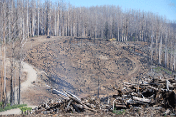
Salvage logging, which occurs quickly after fires, before the timber becomes unsaleable, is a double disturbance: fire is followed soon after by intensive clearfell logging. Up to 85% of the soil layer can be disturbed in this process with the ecological consequence that germinating plants across the harvested area are killed. The impacts of salvage logging can be prolonged, possibly for as long as 200 years.
Credit: David Lindenmayer.

Message of hope


The lead author of Forest Phoenix, Professor David Lindenmayer, has a long history of studying the wet montane forests of Victoria’s Central Highlands, which began with field studies of Leadbeater’s possum 27 years ago. Since then, his research career has led him to investigate the broader biodiversity of these forests, and the impacts of fire ecology, logging impacts and climate change.


‘A lot of the research has got to do with understanding how the system works – with forest pattern and ecological process,’ Prof. Lindenmayer says.


He is sceptical about the public perception that prescribed burning of wet montane forests will protect them from intense wildfires in future.


‘It’s important that we realise that infrequent, intense burning is the kind of fire system this forest has evolved with over the past 20 million years,’ he says. ‘Any burning of a young regenerating forest comprised of trees less than 20–30 years old risks killing all of the trees and losing the forest altogether, along with the myriad of plant and animal species associated with it. Prescribed burning also accelerates the loss of hollow trees; old hollow tree cavities and dead wood are more likely to burn faster.’


Lindenmayer says the message in Forest Phoenix is one of hope – that the magnificent montane ash forests are recovering, despite the scale and intensity of the 2009 fires.


And while he holds out some hope for the future of Leadbeater’s possum, much will depend on the timing and intensity of the next fire, and whether the recovering areas are disturbed by logging.


‘If we don’t salvage log those areas, particularly old forests, Leadbeater’s possum as a species may make it through. But we must remember, it’s got the cards stacked against it – 80 per cent of its distribution is in areas broadly designated for logging,’ he says.


More information:

Lindenmayer D, Blair, D, McBurney L and Blair, D (2010). Forest Phoenix: How a great forest recovers after wildfire (2010) CSIRO Publishing, www.publish.csiro.au/pid/6426.htm


The traditional kind of logging in montane ash forests is clearfelling. Of the areas of montane ash forest subject to logging, more than 95 per cent are clearfelled. Under this method of cutting, virtually all standing trees are removed from a 15–40 hectare area in a single operation, leaving few live standing trees.

Clearfelling has been a highly controversial form of logging in Australian forests, in part because of its impacts on values such as biodiversity conservation. In particular, it either removes the majority of large old trees from a stand, or rapidly accelerates the decay and collapse of those large trees that are retained. These key attributes of forests do not redevelop in a harvested area for a century or more.

Clearfelling is also the typical form of post-fire salvage logging in montane ash forests. The forests therefore undergo a double set of disturbances – wildfires followed by logging.

If left undisturbed by logging after fire, old growth forests will produce large hollow trees suitable for Leadbeater’s possums within 10–15 years. However, much of the species’ range is in logging-designated areas.
Credit: Mike Greer & David Lindenmayer.

Salvage logging is common after major disturbances such as the 2009 wildfires, and aims to recover some of the economic value of fire-damaged trees. Ecologically, however, dead trees created by a fire are important and valuable biological legacies. Salvage logging removes most of the standing timber, and the forest that regenerates is a single age class. In contrast, a burnt forest that is not salvage logged will develop a complex structure composed of young regenerating trees plus living and/or dead trees remaining from the previous stand – ideal habitat for species such as Leadbeater’s possum.
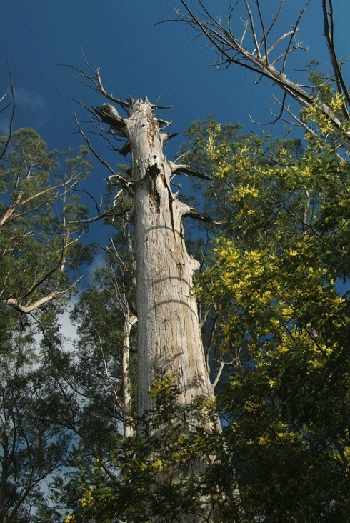
A classic hollow ‘stag’ tree favoured by Leadbeater’s possum: this tree was killed in the 1939 Victorian fires and has remained standing for more than 70 years.
Credit: David Blair

Recent research has attempted to develop alternative logging methods to clearfelling that better retain the key features of forests needed by biodiversity. One method showing some promise involves the retention of islands of forest within cut blocks of forest, creating a combination of old trees and regrowth forest, or ‘multi-aged’ forest.

Multi-aged montane ash forests are very important environments for a range of species; for example, they contain the highest species diversity of arboreal marsupials. Therefore, the island-retention method of logging is more likely to retain suitable habitat for a number of key species in montane ash forest, including Leadbeater’s possum.

The loss of significant stag trees in the 2009 fires led to the establishment of a nest box site for Leadbeater’s possums in snow gums on Lake Mountain.
Credit: David Blair


Published: 25 October 2010

Atlas to put ‘citizen apps’ on the menu


How can we better integrate data from the many disparate citizen science1 groups around the country to improve the nation’s biodiversity monitoring and research efforts? Coordinators at the Atlas of Living Australia project have been spending time with members of community environmental groups to identify the most effective features for a citizen scientists’ online ‘toolkit’.

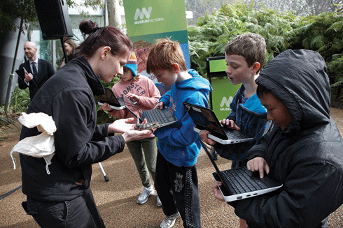
Schoolchildren learn how to use the Biodiversity Snapshots application for mobile devices.
Credit: Museum of Victoria

The rapid development of web, map and mobile-based applications in recent years is making it easier for non-scientists to get access to scientific information and to record observations in the field – sometimes for later scientific use.

For example, Museum Victoria has just launched Biodiversity Snapshots, a new mobile application designed to help Year 3–10 school students and their teachers learn more about native wildlife.

The application includes a field guide with photos and sounds of each animal, and a way to record and upload observations on a mobile phone, netbook or tablet. When a student accesses Biodiversity Snapshots on a mobile device, the application presents information such as the animal’s name, shape, features, distribution, behaviour, habitat, sounds, status and ecology. It also lets students survey species found in school grounds, backyards, urban parks, bushland or coastal environments.

Biodiversity Snapshots is a collaboration between Museum Victoria, the Victorian Department of Education and Early Childhood Development, the Atlas of Living Australia and Earthwatch.

Gaia Resources, the consultancy that designed Biodiversity Snapshots, is also developing tools for citizen science groups to collect, organise and edit their data online through the Atlas of Living Australia website (see ECOS 153, p 24). The design process was kicked off earlier this year, with a series of workshops in which members of citizen science groups identified desirable features for an online toolkit. Not surprisingly, ‘easy to use’, ‘portable/mobile’, ‘fast’ and ‘free’ were at the top of their wish lists.

Harnessing the power of people


The combination of citizen science and new technology has produced some interesting projects. Recently, Einstein@home, an online citizen science astronomy project, described what are believed to be the first pulsars discovered through public participation. More than 250?000 volunteers helped Einstein@home to discover more than 100 potential pulsars.


Another international astronomy project, Galaxy Zoo, invited volunteers to judge from images whether galaxies were elliptical or spiral; and, if spiral, whether they were rotating in a clockwise or anti-clockwise direction.


By mid-2007, 80?000 volunteers had already classified more than 10 million images of galaxies. The final Galaxy Zoo datasets contain more than 34.6 million clicks by 82?931 volunteers: a demonstration of the power that citizen science can harness. According to a member of the Galaxy Zoo team, it would have taken researchers years to process the photographs without the volunteers.


Two other unusual initiatives are National Geographic’s archaeology project ‘Field Expedition: Mongolia’, and the San Francisco Neighborhood Parks Council’s ‘ParkScan’ website.


Volunteers in Field Expedition: Mongolia tag potential archaeological dig sites on GeoEye satellite images to assist explorers on the ground in Mongolia (see http://exploration.nationalgeographic.com).


The ParkScan website allows San Franciscans to monitor the condition of city parks and submit park observations directly to City staff (see www.parkscan.org).


The first beta public release of the Atlas of Living Australia website – which has been referred to as a biodiversity ‘yellow pages’– has been scheduled for late October 2010. The website will give researchers and the wider community access to Australian plant, animal and microorganism species’ names, photos, lists and distribution maps, mapping and identification tools, occurrence records, online literature, natural history collections and herbaria, and ecological, observational, and molecular data.

With data from museums, universities, CSIRO, herbaria and other biological collections linked together within a single web environment, users will be able to explore and analyse the information in new ways to develop a more detailed picture of Australia’s biodiversity.

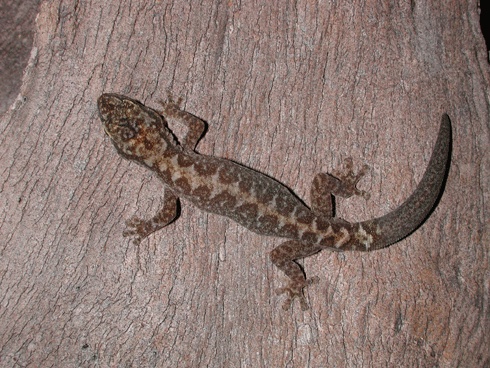
Can you name this gecko, or this tree? The Atlas of Living Australia will provide open access to data such as species names, distribution maps, and mapping and identification tools for reliable identification.
Credit: David McClenaghan

‘The Atlas aims to enable any user to quickly locate and access information across the Internet on all aspects of Australian biodiversity,’ says the Director of the Atlas of Living Australia, Mr Donald Hobern.

For example, users will be able to use the Atlas’ mapping and spatial analysis tools to create a species list for a given area, or map the known occurrence for a species.

The Atlas – which is coordinated by CSIRO – will also give users open access to 50 years of archival material from the Australian Journal of Zoology (a contribution from CSIRO Publishing, which publishes ECOS).

From twitchers to storm chasers

People often ask whether citizen scientists contribute to ‘real’ science. With the right support and coordination, the answer is ‘yes’.

In 2009, for example, the North American Audubon Society analysed 40 years of data from its annual bird count, revealing dramatic shifts northward for winter bird populations as a result of warmer winters. This year's count will help scientists understand the impact of the Gulf oil spill on vulnerable species.

In this country, Birds Australia coordinated a continent-wide survey of birds from 1998–2002, in which thousands of members of the public participated – equipped with binoculars, field guides, GPS units and notebooks. These efforts culminated in the 2003 New Atlas of Australian Birds, presenting 4000 distribution maps for more than 650 bird species, including seasonal changes and breeding range.

Currently, more than 7000 volunteers continue to build Birds Australia’s database of seven million records of birds – the largest biological database in Australia, and one of the largest in the world. Apart from being used by qualified scientists in research projects, the data contributes to Australia’s ‘State of the Environment’ reporting.

Birdwatchers are among the oldest communities of ‘citizen scientists’.
Credit: Rosemary McArthur.

Perhaps the best-known citizen science program in Australia has been the national network of more than 6000 volunteer ‘weather watchers’ coordinated by the Bureau of Meteorology. The volunteers record rainfall, spot storms, and observe river heights and conditions at sea for the Bureau’s weather databases.

Today, members of the public can join any number of citizen science groups, such as ClimateWatch, Frogwatch, Toadbusters, Waterwatch, Operation Spider, Seagrass Watch, Coastcare, Greening Australia, Carnaby's Black-Cockatoo Recovery Project, Conservation Volunteers, Shorebirds 2020 and the Threatened Bird Network.

Of course, an effective citizen science project requires effective volunteer training, technical support, data collection, coordination and encouragement. While data quality can be an issue, innovative tools for ensuring high-quality data are starting to come online. Data collected by volunteers may also need peer review or expert validation.


More information

Atlas of Living Australia, www.ala.org.au


1 Citizen science is the current term for what used to be called ‘amateur science’ or ‘natural history’.


ECOS Archive

Welcome to the ECOS Archive site which brings together 40 years of sustainability articles from 1974-2014.

For more recent ECOS articles visit the blog. You can also sign up to the email alert or RSS feed