|
Published: 31 October 2011
Will Shark Bay’s seagrass meadows survive big floods?
Scientists are studying the impact of a massive influx of fresh water and sediment to Shark Bay in Western Australia as a result of the area’s largest ever flood event recorded in December last year.

|
|
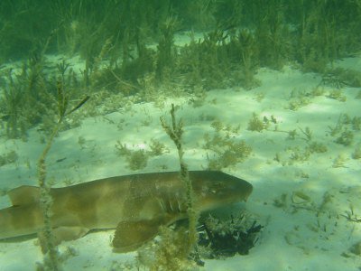
A lone bamboo shark, one of the many animals in the Shark Bay food chain that ultimately depend on the seagrass beds. Credit:
Mat Vanderklift
|
Shark Bay was declared a World Heritage Area in 1991, and has the distinction of being one of the few places in the world that satisfies all criteria for World Heritage listing.
The bay’s vast seagrass meadows – the most diverse assemblage of seagrasses in the world – support globally significant populations of endangered dugongs and turtles.
‘Seagrasses are important as the basis of the bay’s food web,’ said CSIRO researcher, Dr Mat Vanderklift. ‘An array of invertebrates feed on them, fish feed on the invertebrates, and predators like dolphin feed on the fish.
‘The meadows also provide a nursery for juveniles of many species, including crabs and prawns.’
As well as the CSIRO Wealth from Oceans Flagship, the flood-impact study involves The University of Western Australia (UWA), Curtin University and the WA Marine Science Institution.
UWA scientists have additionally been monitoring the biosequestration potential of the seagrass meadows. Carbon from dead seagrass remains in the sediment, while epiphytes living on the seagrasses produce carbonates that form sediment – adding to the bay’s carbon-fixing potential.
While the Shark Bay area is arid and tends to receive little rainfall, it occasionally experiences heavy rain. In December 2010, the town of Carnarvon received 90 per cent of its annual rainfall in a single day.
Researchers have since completed two expeditions to the bay collecting data that will help them understand the response of seagrasses and the fauna they support to extreme events such as floods, which could occur more frequently under climate change scenarios.
The team has already noted evidence of floods impacts, including accumulation of sediment deposited by the flood-plume and extensive loss of leaves on larger seagrasses.
‘The data we collect will also be used in modelling studies looking at other climate change effects, including higher regional temperatures and sea level rise,’ says Dr Vanderklift.
‘Shark Bay is near the northern range limit of many southern coastal species such as Posedonia australis – one of the bay’s main meadow-forming seagrasses. Higher average temperatures might reduce the ability of these species to survive in the bay.’
Dr Vanderklift says the bay’s future could be made more secure by land management actions that reduce the amount of sediment washed into the bay during floods.
Source: CSIRO


