|
Published: 2 December 2013
Cave gauges to monitor underground water ‘bank’
Australia’s limestone caves hold clues to Australia’s groundwater – the nation’s most important savings bank of fresh water, a leading water scientist says.

|
|
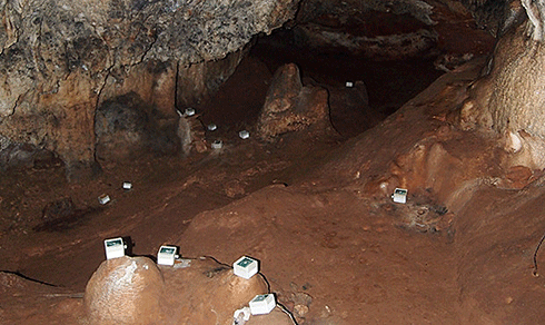
Drip loggers to measure water flow in Cathedral Cave, Wellington, NSW. Credit:
NCGRT
|
As the nation comes to rely increasingly on groundwater to sustain cities, mining and agriculture, it will be crucial to find out how its aquifers get refilled in order to avoid over-extraction, says Professor Andy Baker of the National Centre for Groundwater Research and Training (NCGRT) and The University of New South Wales (UNSW).
‘We’re facing a global water crisis, and we need to know if we’re using our groundwater sustainably, and correctly predict the recharge rates of our aquifers,’ Prof. Baker says. ‘Observing water movement in caves is a cheap and reliable way to do this.’
Prof. Baker and his team have been using caves as ‘underground rain gauges’ to measure the amount of water passing through them. He explains that water flow is extremely uneven – at times of prolonged rainfall, the water can flow very rapidly, but at other times it can be months or years before groundwater recharge happens.
The challenge of measuring groundwater levels or predicting its recharge rate is obviously that groundwater is underground, out of sight and therefore not visible to the naked eye, he says. While water managers can drill boreholes into the ground, this is costly and only indicates how much water is available at a particular point in the aquifer, not how or when it got there.
‘The great thing about caves is you can just walk into them and observe how the water infiltrates into the ground,’ Prof. Baker says. ‘And some caves can be found leading down to an aquifer, and you can directly see the water table.
‘It’s like standing in a house with a leaky roof. As the water drips and travels through the cave, we can measure where it comes in, how much comes in, and where it goes.’
In an ongoing study, the NCGRT researchers have installed the world’s largest collection of drip-water measuring devices in Wellington Caves, located in New South Wales. Prof. Baker explains that the drip loggers behave like mini-drums: ‘Each time the water drips, it triggers a vibration, which is then recorded by a data-logger.’
The scientists can then compare the results with recharge estimates created by mathematical models. ‘It’s a cheap, unique and easy way of testing whether the mathematical predictions that we have are correct.’
Prof. Baker says the study shows that as water travels through the ground, a lot more of it was lost than expected. ‘We created an artificial rainfall in one area and only one per cent of the water ended up in the cave.
‘We don’t know where the rest went – it could have evaporated, flowed somewhere else, or been taken up and transpired by trees and plants.
‘This is why observing water movement in caves is useful – it gives you a realistic measurement of what the aquifer might receive, because the groundwater is only ‘locked up’ when it reaches the water table.’
The team also plans to explore stalagmites in the caves, Prof. Baker says. ‘Stalagmites can only grow if there’s groundwater recharge. If we can find out when they grew in the past, we should be able to estimate when groundwater recharge has occurred.
‘Australia has many limestone caves – they’re widespread across eastern Australia, and there are many on the coast stretching from Western Australia through South Australia to New South Wales. So there’s big potential for using them as observatories of water movement, and it’s an accurate way of predicting when a particular aquifer will be recharged.’
Results from the Wellington Caves experiments are being presented at the world’s largest geoscience conference, the American Geophysical Union Fall Meeting in San Francisco, 11-13 December.
Source: NCGRT


