|
Published: 27 February 2012
Fire channelling: predicting the unpredictable in bushfires
Despite nearly a century of scientific enquiry, there is still much we don’t understand about large fires in the landscape. This is highlighted by a recent study that identifies a previously undocumented form of bushfire propagation – one that can have a potentially catastrophic effect on fires in rugged terrain.
The January 2003 Alpine fires in south-eastern Australia rivalled the notorious Australian 1939 bushfires in severity and extent. On the afternoon of 18 January 2003, fires that had been burning in rugged terrain to the west of Canberra spread into the national capital with tragic consequences including four lives lost. Then, on 26 January, the onset of unfavourable fire weather conditions escalated the fires in the Snowy Mountains – with ongoing ecological and cultural impacts.
The fires grew over 60 days, and eventually became one continuous burnt area from central Victoria to the north of Canberra. When the fires were finally declared contained and controlled on 7 March, a total area of 1.73 million hectares across two Australian states and a territory had been burnt. At least 551 houses had been destroyed and significant amounts of other property and livestock had been lost.
The Alpine fires of 2003 also stand out as some of the best-documented bushfires in Australia. As such, they provide a unique opportunity to better understand the physical processes driving the development of catastrophic bushfires.
The fires were documented by aerial and terrestrial photographs and data from video, satellite and airborne remote sensing platforms. A piloted aircraft fitted with remote-sensing recording equipment flew several missions over fire-affected regions. Multispectral line-scanning equipment mounted on the plane collected measurements of surface radiation through a sensor that swept back and forth as the aircraft flew over the fireground and its surrounds.
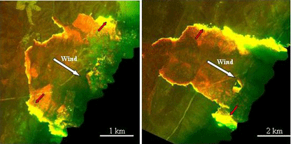
Once the data were processed, researchers could use the resulting images to distinguish regions of active flame from regions where flames were dying down, or regions that were smouldering. Some examples are shown in the first image below.
The images arising from the 2003 Alpine fires were examined by a team of scientists working on a collaborative research project. This was conducted as part of the Bushfire Cooperative Research Centre’s HighFire Risk project, and was published in The International Journal of Wildland Fire . The analyses revealed instances of highly unusual bushfire propagation, which the team termed ‘fire channelling’ events.
Fires are normally expected to spread fastest upslope and in the direction of the wind. However, fire channelling involves intense and rapid spread across lee-facing slopes (i.e. slopes facing away from the wind, where fire behaviour would normally be expected to be milder), nearly perpendicular to the wind direction. It was impossible to explain the 2003 fire-spreading patterns in terms of known forms of bushfire propagation.
Twenty-three instances of fire channelling were identified, characterised by (see the first image below):
-
rapid lateral propagation of the fire flank, including instances of lateral spot-fire development
-
downwind extension of the active flaming zone for 2–5 kilometres
-
a distinct ‘kink’ in the upwind edge of the fire perimeter
-
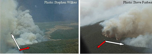
distinctive darker smoke on the advancing flank of the fire (see the second image below).
Further analysis of the images, in combination with wind and topographic data, revealed that fire channelling was most likely caused by a complex interaction between wind, terrain and an active fire. Three key preconditions were necessary:
-
a steep lee-facing slope (incline greater than about 25°) with a topographic aspect within about 40° of the direction the wind is heading
-
strong winds (more than about 25 kilometres per hour)
-
a fire on the lee-facing slope.
Under these conditions, lee slope eddies form. These are strong winds, separate from the surface in the lee of a ridge, which curl around onto themselves to form rotor-like structures. In parts of the terrain prone to lee slope eddies, the winds will mostly blow upslope against the main wind direction. The rapid lateral spread associated with fire channelling is driven by the interaction between a fire burning on the lee slope and the separated flow that forms over the lee slope above the eddies.
The fire behaviour associated with the rapid lateral spread is intense and highly turbulent, increasing the production of embers. As the fire moves across the slope, the embers are incorporated into the main airflow, borne aloft and then deposited downwind. This leads to greater fire-spotting in the short-to-medium range.
Overall, fire channelling therefore produces a ‘swarm’ of embers that simultaneously widen and deepen the region of active flaming.
Fire channelling behaviour has since been confirmed through further research involving collaboration between the University of New South Wales, the ACT Emergency Services Agency, the University of Coimbra (Portugal) and the University of Canterbury (New Zealand).
Continuing research is providing new insights into other notable bushfires, such as the 2009 Black Saturday bushfires. Fire channelling has already been cited as playing a role in the development of the Bunyip and Kilmore East fires.
The research findings also raise questions about the effectiveness of established mitigation practices, including fuel reduction burning and vegetation removal around houses. A consequence of fire channelling is the mass production of embers, such as on Black Saturday and the ember storm that descended on Canberra suburbs in January 2003. We must re-evaluate fuel reduction burning and preparedness of houses and other properties to minimise the impacts of ember attack.
The fire channelling phenomenon has clear implications for fire management. Fire channelling is a very efficient mechanism for spreading a fire across a landscape, and the intense and expansive fire behaviour associated with it has been directly linked to the formation of ‘fire thunderstorms’. These are the most catastrophic stage of fire development (see the first image above).
Fire channelling also holds implications for firefighter and community safety, and the public inquiry and education processes that inevitably follow catastrophic fires. The rapid escalation of a small fire due to fire channelling can compromise safety to an extent that is unpredictable using current operational bushfire behaviour models.
During the 2003 Canberra fires and the 2009 Victorian fires, nobody knew that a fire could behave in such a way. However, improvements to systems for providing advice to the community during extreme bushfire events may need to wait while the science progresses. Without a proper understanding of the physical processes driving large bushfires, there is a risk of disseminating information that will make the community less safe, not more.
Another outcome of the research has been demonstrating the importance of careful observation of bushfires, including the use of sophisticated remote sensing technology. Much of the knowledge arising from recent bushfires has depended on the forethought and planning of fire agencies and others, who have put these monitoring systems in place in the lead-up to the fire season.
Dr Jason Sharples is a lecturer with the School of Physical, Environmental and Mathematical Sciences, University of New South Wales (UNSW Canberra) and formerly a researcher with the Bushfire Cooperative Research Centre (CRC). The project discussed here was a Bushfire CRC-funded collaboration between researchers at UNSW Canberra, the ACT Emergency Services Agency and ACT Territory and Municipal Services.


